


N5 Net Software Repository
Your one-stop for all your software needs.
Search N5 Net Software Repository:
Search Files
Sponsor:
Browse:
- Audio & Multimedia (1582)
- Business (1741)
- Communications (469)
- Desktop (134)
- Development (571)
- Education (165)
- Games & Entertainment (709)
- Graphic Apps (683)
- Home & Hobby (106)
- Network & Internet (544)
- Security & Privacy (505)
- Servers (67)
- System Utilities (9267)
- Web Development (284)
Areas Of Interest
Authors Area
Are you a software author? Take a look at our Author Resource Center where you will find marketing tools, software specifically created for promoting your software and a ton of other helpful resources.
Geodata Germany 29.05
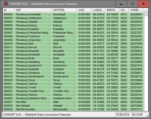
(Click to Enlarge)
The database tables contains geodata of the Federal Republic of Germany with geo referenced towns, municipalities, town quarters and other administrative units, postal codes, telephone preselections, nature areas, landscapes, climatic zones and official topographical cartographies. The data contain coordinates for navigation and geo-coding, proximity searches and distance computations and are prepered for the spatial mapping of environmental information. Quite often it is necessary to reference an address field e.g. like town or municipality name, postal code or telephone preselection, to corresponding geographical data and coordinates - a Geo Reference. The geo reference can be used e.g. to direct a customer to the closest store locations of a retail store chain by doing a proximity search. Another possibility it to determine distances between the different objects of the database tables with the included geo references. With the elevation data from a Digital Elevation Model the ground level height of each place can be determined. Often the knowledge is necessary about affiliations and relationships between data derived from different hierarchies. So it can be determined to which federal state, governmental area or governmental county a town, a postal code or a telephone preselection is associated. It is possible to assign a variety of natural and scenic information to each town or municipality. The snow and wind load zones and solar irradiation are available as local climatic data. In conjunction with the ground level heights they can be used to calculate static loads for the planning of building constuctions and to calculate solar installations. Databases: 11.500 Towns and Municipalities, 108.000 Town Quarters, 31.000 Postal Codes, 19.500 Telephone Preselections, all with geo references, 400 Administrative Countys, Administrative Districts, Federal States of Germany, Landscapes, Nature Area Classification, Snow and Wind Load Zones, Solardata, Cartographies.
Specifications:
Version: 29.05 |
Download
|

Similar Products:
SSIS DATA FLOW COMPONENTS 4.0.0
Business :: Databases & Tools
 Devart SSIS Data Flow Components allow you to integrate database and cloud data via SQL Server Integration Services (SSIS). They provide easy to set up cost-effective data integration using SSIS ETL engine. Devart SSIS Data Flow Components deliver high performance data loading, convenient component editors, SQL support for cloud data sources and lots of data source specific features.
Windows | Shareware
Read More
Business :: Databases & Tools
 Data base software with serial letter function with personalized recipient
Windows | Shareware
Read More
DBFORGE SEARCH FOR SQL SERVER 2025.3
Business :: Databases & Tools
 Search for SQL Objects and Table Data in SSMS with ease. dbForge Search for SQL Server is a FREE add-in for Microsoft SQL Server Management Studio that allows you to quickly locate SQL objects, data, and text in your databases.
Windows | Freeware
Read More
DBFORGE STUDIO FOR MYSQL 2025.3
Business :: Databases & Tools
 dbForge Studio for MySQL is a universal GUI tool for MySQL and MariaDB database development, management, and administration. The IDE allows you to create and execute queries, develop and debug stored routines, automate database object management, analyze table data via an intuitive interface. The MySQL client delivers data and schema comparison and synchronization tools, database reporting tools, backup options with scheduling, and much more.
Windows | Shareware
Read More