


N5 Net Software Repository
Your one-stop for all your software needs.
Search N5 Net Software Repository:
Search Files
Sponsor:
Browse:
- Audio & Multimedia (3039)
- Business (5565)
- Communications (1642)
- Desktop (531)
- Development (1260)
- Education (505)
- Games & Entertainment (1131)
- Graphic Apps (1290)
- Home & Hobby (269)
- Network & Internet (1005)
- Security & Privacy (1246)
- Servers (129)
- System Utilities (32725)
- Web Development (518)
Areas Of Interest
Authors Area
Are you a software author? Take a look at our Author Resource Center where you will find marketing tools, software specifically created for promoting your software and a ton of other helpful resources.
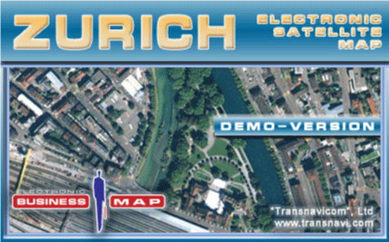
Transnavicom Satellite Map of Zurich 1.0
(Click to Enlarge)
Demo-version of Satellite Map of Zurich! The newest developments and progressive experience of Transnavicom (www.transnavi.com), professionalism of our specialists, aspiration and wish to do our favourite thing give us a chance to create such high-quality and unique products! Face the reality! Your dreams are coming true with satellite maps from Transnavi.com. In the demo-version you can get acquainted with a district of Zurich, use address-search functions and measure the distance between any number of points! Basic properties of the programme demo-version: Spatial resolution - 60 centimeters in one pixel allows to have a detailed look at buildings, smallest curves of streets, cars on the streets, elements of road marking and even crowds of people on Zurich streets. Multilevel scaling function enables changing zooming in and out ranging from a panoramic view of the city to the detailed configuration of the building. Quick navigation enables to move quickly on the map in any direction. Moving is fulfilled simultaneously with the mouse movement without any pauses on the monitor. Searching system by the name of the street and postal address. Revealing information about objects. When pointing the cursor at the object (street, building, a reference window with information about this object appears. The functional Navigator function makes the orientation and navigation around the map easier. Measuring distances of the map between any number of consequently put points. Printing any fragment of the map of any scale model. Changing and customer-friendly interface of the programme. Possibility to choose the operation language: English, German, Russian. After choosing the language all interface elements, including messages, hints, names of objects in data bases (streets, districts).
Specifications:
Version: 1.0 |
Download
|

Similar Products:
Home & Hobby :: Other
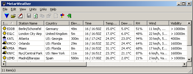 The MetarWeather utility decodes METAR weather reports from around the world, and displays them in a simple weather report table. You can save the weather report into a text or HTML files. MetarWeather can decode METAR reports from a text file, or download the latest reports directly from the Internet.
Windows | Freeware
Read More
Home & Hobby :: Other
 MorseTest is a program to help radio hams improve their Morse receiving skills. Modelled on a contest, the aim is to correctly copy as many calls and serial numbers as you can. It's one of the best ways to improve your code receiving speed.
Windows | Freeware
Read More
Home & Hobby :: Other
 If you use Google Earth to prepare for your Geocaching trips, then you'll know that it's often difficult to find the right caches and to see which ones you already visited. This program makes it easier by preparing your GPX files for Google Earth. Now you can see which caches you've already visited, which ones are out-of-order and which ones you own. Requires GPX files with the cache information.
Windows | Freeware
Read More
Home & Hobby :: Other
 Program to decode Morse code (CW) via sound card to text. It can work as narrow-band sound DSP-filter also. No additional hardware required - your need only receiver and computer (5x86-133 or better) with sound card. Can cooperate with RZ4AG AAlog logger. It is software Morse decoder that REALLY work!
Windows | Shareware
Read More