


N5 Net Software Repository
Your one-stop for all your software needs.
Search N5 Net Software Repository:
Search Files
Sponsor:
Browse:
- Audio & Multimedia (1582)
- Business (1741)
- Communications (469)
- Desktop (134)
- Development (571)
- Education (165)
- Games & Entertainment (709)
- Graphic Apps (683)
- Home & Hobby (106)
- Network & Internet (544)
- Security & Privacy (505)
- Servers (67)
- System Utilities (9267)
- Web Development (284)
Areas Of Interest
Authors Area
Are you a software author? Take a look at our Author Resource Center where you will find marketing tools, software specifically created for promoting your software and a ton of other helpful resources.
DEVELOPED SECTION 1.8
Graphic Apps :: CAD
(Click to Enlarge)
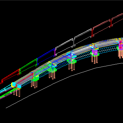
An add-on for AUTOCAD or BricsCAD, which determines the unfolded section of one set of 3DSOLID, 3DMESH or 3DFACE entities and vertical planes passing through a 2D POLYLINE which may contain arcs, in XOY plane. Developed section is generated in the vertical plane passing through first segment of POLYLINE. The intersection is generated in the form of 3DPOLY entities, colored from 1 to 1, beginning with the color 1, corresponding to every vertical plane. The result is automatically generated in viewports ready for printing. You can set also the "concatenation precision" of the segments of intersection. There is also another command that generates drawings in PDF format, for several rectangular areas from a DWG. Without this new command you would have wasted time, manually entering the PLOT command and its options, in repeatedly.
Specifications:
Version: 1.8 |
Download
|

Similar Products:
CUTTING OPTIMIZATION PRO 5.18.20.1
Graphic Apps :: CAD
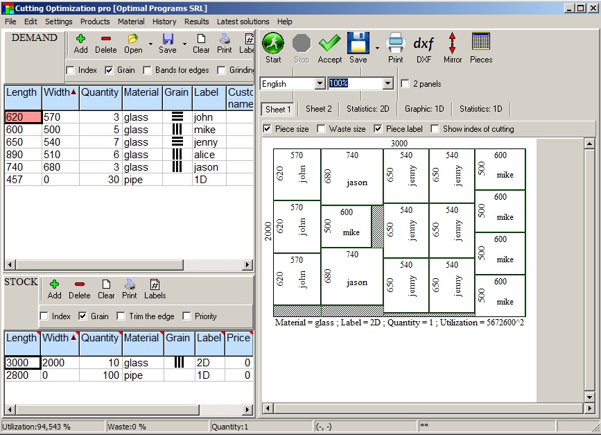 Cutting Optimization Pro is a computer program used for obtaining good cutting and nesting layouts for one (1D) and two (2D) dimensional pieces. It can be used for cutting and nesting of rectangular sheets made of glass, wood, metal, and linear pieces such as bars, pipes, tubes, steel bars, metal any other material. The software lets you to define and handle complex products, such as table, desk, cupboard, locker, book shelf, etc.
Windows | Shareware
Read More
CUT AND FILL VOLUME IN AUTOCAD 1.5
Graphic Apps :: CAD
![]() Cut and fill volume is an add-on for AutoCAD or BricsCAD, with new commands for scale modification for LINETYPE and HATCH, registration of mileage in BLOCKs, modification of longitudinal profiles, cut and fill volume, DWG to custom Hatch pattern, 3D axis and roadside, starting from 2D and 4 viewports with views at the same scale in the XOY, XOZ, YOZ planes and in 3D.
Cut and fill volume is an add-on for AutoCAD or BricsCAD, with new commands for scale modification for LINETYPE and HATCH, registration of mileage in BLOCKs, modification of longitudinal profiles, cut and fill volume, DWG to custom Hatch pattern, 3D axis and roadside, starting from 2D and 4 viewports with views at the same scale in the XOY, XOZ, YOZ planes and in 3D.
Windows | Data Only
Read More
AUTOLISP SOURCE CODE FOR PROGRAMMERS 1.5
Graphic Apps :: CAD
 AutoLISP source code can be run on AutoCAD or IntelliCAD (Bricscad, ProgeCAD, Cadopia, etc.), on any number of computers. There are programs for: Triangulation, Load XYZ and 4D files, B-spline control polygon and interpolated contour lines, Intersect 2 3DFACE and contour lines, Modify longitudinal profile, converts a DWG file to an XYZ file of points and custom "Hatch styles from a DWG". There are shareware versions. The price is per program.
Windows | Data Only
Read More
Graphic Apps :: CAD
![]() The most convenient program for: loading and drawing XYZ files of points, triangulation, contour lines and color-filled contour maps. You can also draw 4D points cloud and process hundreds of thousands of points or triangles, even on less powerful PCs. You don't need another CAD system. RTOPO LT has its own CAD system. RTOPO LT is the reduced version of the full RTOPO Hydrology CAD for topography.
The most convenient program for: loading and drawing XYZ files of points, triangulation, contour lines and color-filled contour maps. You can also draw 4D points cloud and process hundreds of thousands of points or triangles, even on less powerful PCs. You don't need another CAD system. RTOPO LT has its own CAD system. RTOPO LT is the reduced version of the full RTOPO Hydrology CAD for topography.
Windows | Shareware
Read More