


N5 Net Software Repository
Your one-stop for all your software needs.
Search N5 Net Software Repository:
Search Files
Sponsor:
Browse:
- Audio & Multimedia (1582)
- Business (1741)
- Communications (469)
- Desktop (134)
- Development (571)
- Education (165)
- Games & Entertainment (709)
- Graphic Apps (683)
- Home & Hobby (106)
- Network & Internet (544)
- Security & Privacy (505)
- Servers (67)
- System Utilities (9267)
- Web Development (284)
Areas Of Interest
Authors Area
Are you a software author? Take a look at our Author Resource Center where you will find marketing tools, software specifically created for promoting your software and a ton of other helpful resources.
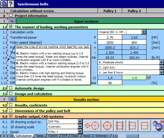
MITCalc 1.73
Graphic Apps :: CAD
(Click to Enlarge)
MITCalc is a multi-language set of mechanical, industrial and technical calculations for the day-to-day routines. It will reliably, precisely, and most of all quickly guide customer through the design of components, the solution of a technical problem, or a calculation of an engineering point without any significant need for expert knowledge. MITCalc contains both design and check calculations of many common tasks, such as: spur and bevel gear, worm gear, planetary gear, gear rack, belt and chain gear, bearings, beam, pins, buckling, shafts, springs, bolt connection, shaft connection, welding, tolerance analysis, tolerances, plates, shells, aerodynamics, technical formulas, aerodynamics, ballistics and many others. There are also many material, comparison, and decision tables, including a system for the administration of resolved tasks. The calculations support both Imperial and Metric units and are processed according to ANSI, ISO, DIN, EN, BS, CSN and Japanese standards. It is an open system designed in Microsoft Excel which allows not only easy user-defined modifications and user extensions without any programming skills, but also mutual interconnection of the calculations, which is unique in the development of tailor-made complex calculations. The sophisticated interaction with many 2D CAD systems (AutoCAD, AutoCAD LT, IntelliCAD, Ashlar Graphite, TurboCAD, BricsCAD, ZWCAD, ProgeCAD) allows the relevant drawing to be developed in a few seconds. The support of 3D CAD systems covers Autodesk Inventor, SolidWorks, Solid Edge and Creo.
Specifications:
Version: 1.73 |
Download
|

Similar Products:
Desktop :: Other
 Extremely powerful suite, full of functions that combine the functionality of some other tools with many new things in a top modern and improved form to enhance your Windows Desktop by a lot. It can boost your productivity by a huge factor and serves as an automation base. Window management, process management, calculations, conversions, file functions, safety features and repair functions make it your optimal Windows companion.
Windows | Freeware
Read More
Business :: Databases & Tools
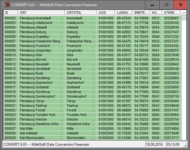 The database contain geodata of the Federal Republic of Germany with geo referenced towns, municipalities, town quarters, administrative units, postal codes, telephone preselections, nature areas, landscapes, climatic zones. The data contain coordinates for navigation and geo-coding, proximity searches, distance computations and for mapping of landscape information. It is possible to assign a variety of nature and scenic information to each town.
Windows | Data Only
Read More
MITCALC SPUR GEAR CALCULATION 1.24
Graphic Apps :: CAD
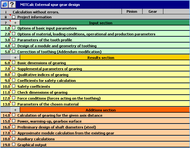 Geometric design and strength check of spur gear with straight and helical toothing. Application is developed in MS Excel, is multi-language and supports Imperial and Metric units. Is based on ANSI/AGMA and ISO/DIN standards and support many 2D and 3D CAD systems (AutoCAD, AutoCAD LT, IntelliCAD, Ashlar Graphite, TurboCAD, BricsCAD, ZWCAD, ProgeCAD, Autodesk Inventor, SolidWorks, SolidEdge, Creo).
Windows | Shareware
Read More
Business :: Calculators & Converters
 Designed for easy performance of date calculations. Adds or subtracts a number of days or months to a date, calculates the number of days between two dates and converts among Gregorian dates, Julian dates, ISO 8601 Week dates, Hermetic Leap Week dates, Julian day numbers and ordinal dates of the form yyyy-ddd. Weekend days, and first and last days, may be included or excluded.
Windows | Freeware
Read More