


N5 Net Software Repository
Your one-stop for all your software needs.
Search N5 Net Software Repository:
Search Files
Sponsor:
Browse:
- Audio & Multimedia (1621)
- Business (4269)
- Communications (1275)
- Desktop (188)
- Development (613)
- Education (177)
- Games & Entertainment (714)
- Graphic Apps (690)
- Home & Hobby (107)
- Network & Internet (577)
- Security & Privacy (529)
- Servers (65)
- System Utilities (11779)
- Web Development (292)
Areas Of Interest
Authors Area
Are you a software author? Take a look at our Author Resource Center where you will find marketing tools, software specifically created for promoting your software and a ton of other helpful resources.
AutoLisp source code for programmers 1.4
Graphic Apps :: CAD

(Click to Enlarge)
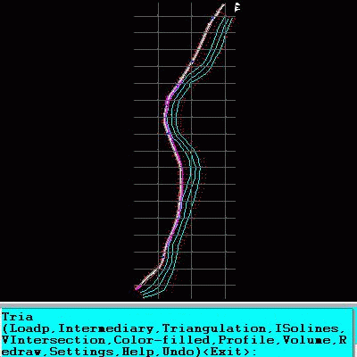
AutoLISP source code can be run on AutoCAD or IntelliCAD (Bricscad, ProgeCAD, Cadopia, etc). They can be modified, included in programs that you sell, and can be run on any number of computers. There are programs for: - "Triangulation" will generate triangular 3DFACE entities, on the convex hull of the set of points, - "Load XYZ and 4D files"; file types: x y z color, x y z scalar, x y z r g b, no. x y z code, - "B-spline control polygon and interpolated contour lines" creates the control polygon and interpolates a POLYLINE with cubic B-Spline; the interpolated curve passes through the initial points and you can control its curvature; you can also generate interpolated contour lines, - "Intersect 2 3DFACE and contour lines" intersects 2 triangular 3DFACE entities and generatea the contour lines, - "Modify longitudinal profile" contains 3 new commands which increase productivity in the modification of drawings YTE changes the Y texts of some points, relative to an origin point, XTE changes the X text of some points, relative to X=0 of the current UCS, PTE inserts elevation and slope with triangle on a POLYLINE, - "DWG to XYZ" converts a DWG file to an XYZ file of points, - "Longitudinal profile and cross sections" for the projection over a triangulation of a 2D POLYLINE is useful for surveyors and designers, - "Cut and fill volume" calculates the filling and digging volumes between the project and the land surfaces; the surfaces must be 3DFACE or 3DMESH entities (created with variable MESHTYPE set to 0), having different colors between project and land, - "Surface Flatness", useful in analyzing the flatness of a point cloud, which must be triangulated beforehand, - Custom "Hatch styles from a DWG". You can test these programs in the programs in which they were implemented: - RTOPO Hydrology CAD for topography, - Topography in AutoCAD or BricsCAD, - 3DINTERSECTION for AutoCAD or BricsCAD, - Cut and fill volume in AutoCAD or BricsCAD.
Specifications:
Version: 1.4 |
Download
|

Similar Products:
Graphic Apps :: CAD
 CAD-COMPO is a combo of popular CAD plug-ins for Illustrator. Your Illustrator will turn into a professional CAD software! BPT-Pro: Adobe Illustrator becomes a highly functional 2D-CAD program with 8 kinds and 19 different tools, all accessible through Illustrator tool box and a convenient information palette. EXDXF-Pro: EXDXF-Pro exports CAD-standard dxf to Illustrator data and imports dxf to Illustrator in great quality.
Windows | Shareware
Read More
Graphic Apps :: CAD
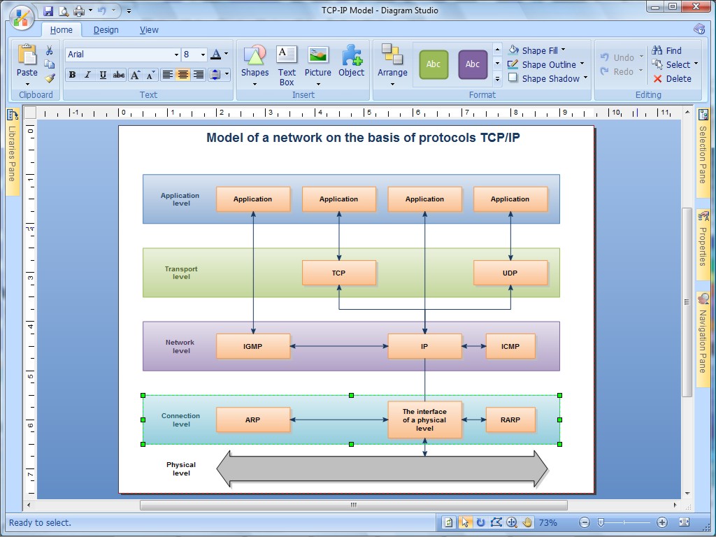 A picture is worth a thousand words. A clear, self-explanatory, striking picture - whether it's a flowchart, diagram, illustration or technical drawing - may be worth a new contract, extra sales channels, more revenue, and additional clientele. DiagramStudio flowchart software is a tool that helps thousands of individuals and organizations create convincing, eloquent and visually appealing presentations.
Windows | Shareware
Read More
EFM - ETECAD FILE MANAGER 2.19.1
Graphic Apps :: CAD
 EFM is a Windows CAD graphics file manager and viewer all rolled in one. EFM completely replaces the Windows Explorer and provides additional features designed to handle CAD and image files.Not only does EFM allow you to view AutoCAD drawings, it can locate, retrieve, archive, convert DWG and PLT files and plot them too. You can attach descriptions to files and directories for easy identification as well as search for drawing files.
Windows | Shareware
Read More
TOPOGRAPHY IN AUTOCAD OR BRICSCAD 2.3
Graphic Apps :: CAD
 An add-on for AUTOCAD or BricsCAD, for the triangulation of a set of POINTS, isolines, DWG to Google Earth, the volume and center of gravity of a set of bodies or between surfaces composed of 3DFACE. You can load a file of points having the format: Number X Y Z Code. You can make cross sections, longitudinal profile and color-filled contour map. You can determine the flatness of the surfaces and you can import and export LandXML file type!
Windows | Data Only
Read More