


N5 Net Software Repository
Your one-stop for all your software needs.
Search N5 Net Software Repository:
Search Files
Sponsor:
Browse:
- Audio & Multimedia (1527)
- Business (1697)
- Communications (462)
- Desktop (135)
- Development (555)
- Education (163)
- Games & Entertainment (700)
- Graphic Apps (657)
- Home & Hobby (102)
- Network & Internet (524)
- Security & Privacy (499)
- Servers (65)
- System Utilities (8668)
- Web Development (279)
Areas Of Interest
Authors Area
Are you a software author? Take a look at our Author Resource Center where you will find marketing tools, software specifically created for promoting your software and a ton of other helpful resources.
Search: topography
Network & Internet :: Other
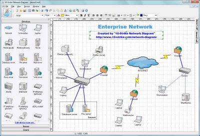 Create a diagram of your local area network quickly with this powerful network diagrammer and mapper, save it in popular graphical formats, copy and paste it to a document and export it to Microsoft Visio for further processing. The program scans your network via the ICMP, TCP, UPnP, and SNMP protocols, automatically discovers topology, builds a graphical network map, displays devices of different types as icons, and draws links between them.
Windows | Shareware
Read More | Download Now
AUTOLISP SOURCE CODE FOR PROGRAMMERS 1.5
Graphic Apps :: CAD
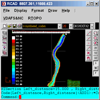
 AutoLISP source code can be run on AutoCAD or IntelliCAD (Bricscad, ProgeCAD, Cadopia, etc.), on any number of computers. There are programs for: Triangulation, Load XYZ and 4D files, B-spline control polygon and interpolated contour lines, Intersect 2 3DFACE and contour lines, Modify longitudinal profile, converts a DWG file to an XYZ file of points and custom "Hatch styles from a DWG". There are shareware versions. The price is per program.
Windows | Data Only
Read More | Download Now
Graphic Apps :: CAD
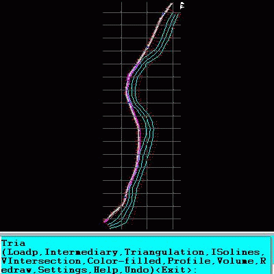
 Simple, powerful and inexpensive CAD software for surveying. You can do triangulation, isolines, color-filled contour maps, sections, intersections, volume, editing XYZ files, simulation of rainwater runoff and much more. You can represent 4D points cloud and process hundreds of thousands of points or triangles, even on less powerful PCs.
Windows | Data Only
Read More | Download Now
Graphic Apps :: CAD
![]() The most convenient program for: loading and drawing XYZ files of points, triangulation, contour lines and color-filled contour maps. You can also draw 4D points cloud and process hundreds of thousands of points or triangles, even on less powerful PCs. You don't need another CAD system. RTOPO LT has its own CAD system. RTOPO LT is the reduced version of the full RTOPO Hydrology CAD for topography.
The most convenient program for: loading and drawing XYZ files of points, triangulation, contour lines and color-filled contour maps. You can also draw 4D points cloud and process hundreds of thousands of points or triangles, even on less powerful PCs. You don't need another CAD system. RTOPO LT has its own CAD system. RTOPO LT is the reduced version of the full RTOPO Hydrology CAD for topography.
Windows | Shareware
Read More | Download Now
TOPOGRAPHY IN AUTOCAD OR BRICSCAD 2.3
Graphic Apps :: CAD
 An add-on for AUTOCAD or BricsCAD, for the triangulation of a set of POINTS, isolines, DWG to Google Earth, the volume and center of gravity of a set of bodies or between surfaces composed of 3DFACE. You can load a file of points having the format: Number X Y Z Code. You can make cross sections, longitudinal profile and color-filled contour map. You can determine the flatness of the surfaces and you can import and export LandXML file type!
Windows | Data Only
Read More | Download Now
Business :: Databases & Tools
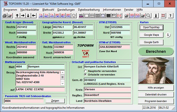 TOPOWIN is a state-wide register of the German topographic cartographies and of localities with geo references in different coordinate systems. It also is a topographic information system. The topographical maps of different standards can be determined by the entering of known parameters or by the direct selection from overview graphics and from sorted lists.
Windows | Shareware
Read More | Download Now
[1]