


N5 Net Software Repository
Your one-stop for all your software needs.
Search N5 Net Software Repository:
Search Files
Sponsor:
Browse:
- Audio & Multimedia (1527)
- Business (1697)
- Communications (462)
- Desktop (135)
- Development (555)
- Education (163)
- Games & Entertainment (700)
- Graphic Apps (657)
- Home & Hobby (102)
- Network & Internet (524)
- Security & Privacy (499)
- Servers (65)
- System Utilities (8668)
- Web Development (279)
Areas Of Interest
Authors Area
Are you a software author? Take a look at our Author Resource Center where you will find marketing tools, software specifically created for promoting your software and a ton of other helpful resources.
Downloading Funny Bricks 2.2
Your download will begin in a few seconds. If it does not start you can download directly through one of the mirror sites below.
- Mirror Site 1: http://www.myplaycity.com/files/funnybrickssetup.exe
Get Details for Funny Bricks 2.2
Similar Products:
TOPOGRAPHY IN AUTOCAD OR BRICSCAD 2.3
Graphic Apps :: CAD
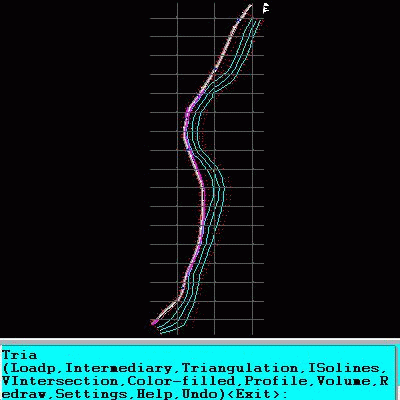 An add-on for AUTOCAD or BricsCAD, for the triangulation of a set of POINTS, isolines, DWG to Google Earth, the volume and center of gravity of a set of bodies or between surfaces composed of 3DFACE. You can load a file of points having the format: Number X Y Z Code. You can make cross sections, longitudinal profile and color-filled contour map. You can determine the flatness of the surfaces and you can import and export LandXML file type!
Windows | Data Only
Read More
Games & Entertainment :: Puzzle & Word Games
 Match3 game is popular in world. The simple mechanics and rules allow earning points by chaotically clicking with a mouse across the field. Differs quite a bit from classic match3. Game Space Lines rethinks the logic of the game created back in 1992. Our version keeps the rules of classical Lines: Each course in the field displays 3 figures, and you must build from them lines on 5 or more identical figures.
Windows | Freeware
Read More
Education :: Geography
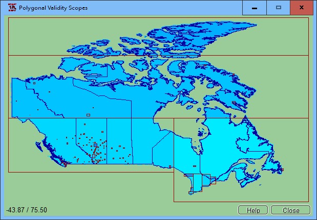 The spatial software NTv2Poly replaces the quadrangular activity scope contained in NTv2 files with a Polygonal Validity Scope, which is realized with an outline file in classic Shape Format. Invalid calculations outside the Polygonal Validity Scope thus can be excluded or acknowledged by a warning. Download the trial version from http://www.killetsoft.de/zip/ntv2poly.zip. Read the Worksheet at http://www.killetsoft.de/t_1808_e.htm.
Windows | Shareware
Read More
AUTOLISP SOURCE CODE FOR PROGRAMMERS 1.5
Graphic Apps :: CAD
 AutoLISP source code can be run on AutoCAD or IntelliCAD (Bricscad, ProgeCAD, Cadopia, etc.), on any number of computers. There are programs for: Triangulation, Load XYZ and 4D files, B-spline control polygon and interpolated contour lines, Intersect 2 3DFACE and contour lines, Modify longitudinal profile, converts a DWG file to an XYZ file of points and custom "Hatch styles from a DWG". There are shareware versions. The price is per program.
Windows | Data Only
Read More
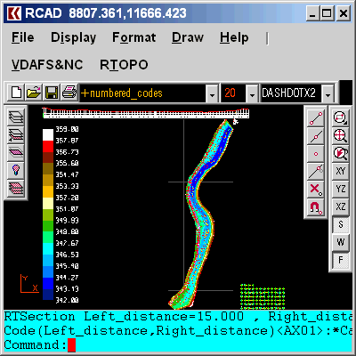
Graphic Apps :: CAD
![]() The most convenient program for: loading and drawing XYZ files of points, triangulation, contour lines and color-filled contour maps. You can also draw 4D points cloud and process hundreds of thousands of points or triangles, even on less powerful PCs. You don't need another CAD system. RTOPO LT has its own CAD system. RTOPO LT is the reduced version of the full RTOPO Hydrology CAD for topography.
The most convenient program for: loading and drawing XYZ files of points, triangulation, contour lines and color-filled contour maps. You can also draw 4D points cloud and process hundreds of thousands of points or triangles, even on less powerful PCs. You don't need another CAD system. RTOPO LT has its own CAD system. RTOPO LT is the reduced version of the full RTOPO Hydrology CAD for topography.
Windows | Shareware
Read More
Graphic Apps :: CAD
 Simple, powerful and inexpensive CAD software for surveying. You can do triangulation, isolines, color-filled contour maps, sections, intersections, volume, editing XYZ files, simulation of rainwater runoff and much more. You can represent 4D points cloud and process hundreds of thousands of points or triangles, even on less powerful PCs.
Windows | Data Only
Read More
Games & Entertainment :: Puzzle & Word Games
 Agile Lines is an extremely addictive variation of the famous Lines game. Remove colored balls from the board by placing them in the rows (or blocks) of five or more. The unique feature of the game is the ability to use JOKER balls that can substitute balls of any color. When you quit the game the current position is automatically saved so you could continue playing later. The game features sleek graphics and impressive video and audio effects.
Windows | Shareware
Read More
HTML REMOVE LINES AND TEXT SOFTWARE 7.0
Web Development :: HTML Tools
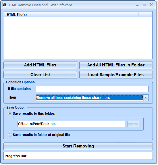 This software offers a solution to users who want to remove specific lines and characters from multiple HTML files including blank lines. There are features to remove entire lines (rows), columns, characters, lines not containing characters, blank lines, etc. This software can save you hours by quickly modifying batches of data.
Windows | Shareware
Read More
Games & Entertainment :: Puzzle & Word Games
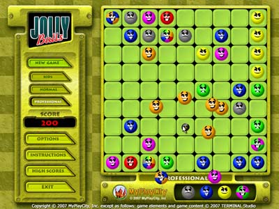 Jolly Balls is an entertaining colorful remake of the old classic Lines game. This new version is full of new features. The balls on the field interact with the player while numerous cool bonus features make the playing experience exciting and fun.
Windows | Freeware
Read More